路虽远行则将至,事虽难做则必成。漫漫长路,必见曙光。《荀子•修身》
课程通知 | 2021年“地理大数据与空间智能”暑期学校三号通知
地理大数据是国家大数据战略实施的重要组成部分,与国家安全、社会经济、智慧城市建设乃至国民日常生活密切相关。近年来,在数据快速发展的时代背景下,地理大数据的深度挖掘与创新应用,成为当前地理学、测绘科学、计算机科学与技术等多学科交叉融合的新方向。与此同时,地理空间智能在地理大数据的支撑之下,持续地推动空
喜报| 我团队在全国高等学校测绘类专业2021年度系列竞赛取得1项特等奖与1项一等奖
由全国高等学校测绘类专业竞赛联盟和自然资源部职业技能鉴定指导中心联合主办、广州南方测绘科技股份有限公司协办的全国高等学校测绘类专业2021年度系列竞赛于贵州大学成功举办。此次比赛共包含3个大项:“南方测绘杯”第十二届全国高等学校大学生测绘科技论文大赛、“华测导航杯”第二届全国大学生测绘创新开发大赛、
课程通知 | 2021年“地理大数据与空间智能”暑期学校二号通知
地理大数据是国家大数据战略实施的重要组成部分,与国家安全、社会经济、智慧城市建设乃至国民日常生活密切相关。近年来,在数据快速发展的时代背景下,地理大数据的深度挖掘与创新应用,成为当前地理学、测绘科学、计算机科学与技术等多学科交叉融合的新方向。与此同时,地理空间智能在地理大数据的支撑之下,持续地推动空
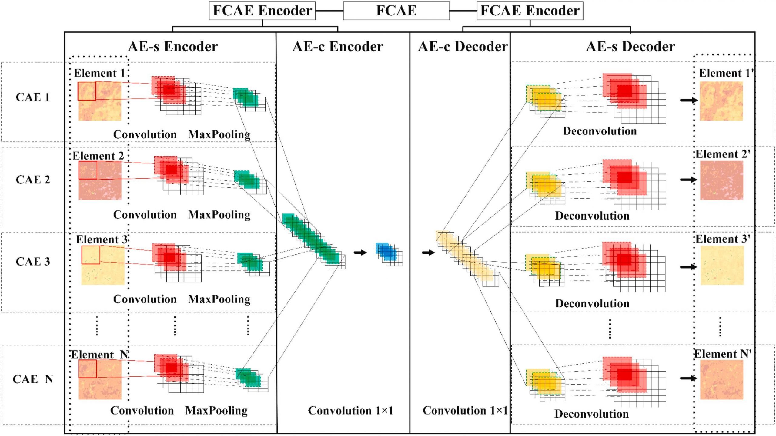
A spatial-compositional feature fusion convolutional autoencoder for geochemical anomaly recognition
ABSTRATThe spatial structural features and compositional relationships of multivariate geochemicals are influenced by complex geological processes (e.
一种用于失踪人群时空定位服务的数据分析方法
专利号:2019 1 0463886.6专利简介:本发明提供了一种用于失踪人群时空定位服务的数据分析方法,包括:通过已有失踪人口数据构建初始数据集;对初始数据集中的数据进行数据筛选和预处理,提取出用于进行分类的指标,得到样本数据集;对样本数据集中的数据进行进一步细化分类,并进行分类标号,得到用于模型
多源空间大数据场景下的家装品牌线下广告选址布局研究
摘要合理进行线下广告牌投放位置的选择,对商家宣传品牌以及扩大营销市场具有十分积极的作用。由于商业数据较难获取,以往研究多停留在宏观理论层面,未能对线下广告选址的实际布局进行细尺度分析。本研究以北京为研究区,通过耦合某大型家装品牌户外广告到店转化率和路网、感兴趣点数据(point of interes
Analyzing correlation between visual space and residents’ psychology using images and deep learning
ABSTRACTAlthough previous studies have assessed the relationships between visual space indicators and urban residents’ psychological perceptions, syst
西安市文化设施的空间集聚特征及影响因素分析——倡导高效化还是侧重均等化?
摘要选取 2019 年文化设施 POI 数据,采用标准差椭圆分析、最邻近指数和核密度估计相结合的方法,首先测度了西安市文化设施的空间集聚特征,进一步基于区位选址理论,结合空间权重矩阵的思想,对比分析了高效化要素和均等化要素对西安市文化设施集聚空间的影响。研究发现 :第一,西安市文化设施呈较为明显的空
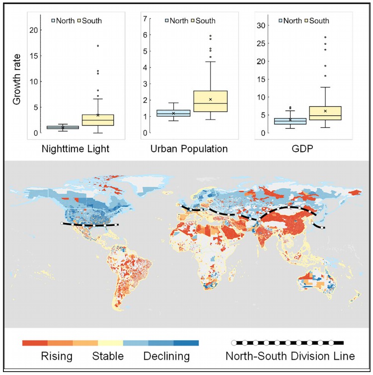
A global North-South division line for portraying urban development
SUMMARYRapid urbanization has tremendously changed the global landscape with profound impacts on our society. Nighttime light (NTL) data can provide v
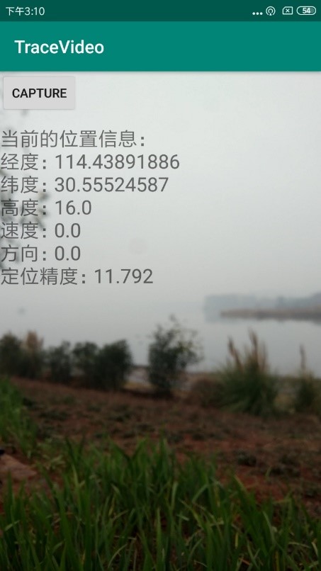
TraceVideo v2.0:带有位置信息的视频流数据采集软件(Andorid版)
TraceVideo v1.0是基于手机视频和传感器,获取位置信息和街景视频流的Android手机软件。TraceVideo v1.0会要求手机的摄像头、GPS和存储权限,在用户移动的过程中,记录视频,及视频的起始、终点时间,和视频记录时间全过程的位置信息。开发者团队研究生 王宇同学:9164910