


Abstract
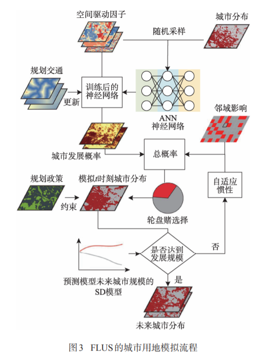
Arising from rapid growth of economy and population,urban sprawl has become a major challenge for sustainable urban development in the world. In order to assist urban planning, applicable methods and models are required to guide and constrain the growth of urban areas. Nowadays, urban growth boundaries (UGBs) has been regarded as a common tool used by planners to control the scale of urban development and protect rural areas which has a significant contribution to local ecological environment. However, existing models mainly focus on the delimitation of UGBs for urban development in single-scenarios. To date, there are rarely studies to develop efficient and scientific methods for delimiting the UGBs by taking the influences of macro policy and spatial policy into account. This paper presents a future land use simulation and urban growth boundary model (FLUS-UGB) which aims to delimit the UGBs for the urban areas in multi-scenarios. The topdown system dynamics (SD) model and bottom-up cellular automaton (CA) model are integrated in FLUS submodel for simulating the urban growth pattern in the future. Furthermore, the UGB sub-model is developed to generate the UGBs that uses a morphological technology based on erosion and dilation according to the urban form produced by FLUS. This method merges and connects the cluster of urban blocks into one integral area and eliminates the small and isolated urban patches at the same time. We selected the Pearl River Delta region (PRD), one of the most developed areas in China, as the case study area and simulate the urban growth of PRD region from 2000 to 2013 for validate the proposed model. Then we used FLUS- UGB model to delimit the UGBs in PRD region of 2050 under three different planning scenarios (baseline, farmland protection and ecological control). The results showed that: (1) the model has high simulation accuracy for urban land with Kappa of 0.715, overall accuracy of 94.539% and Fom 0.269. (2) the method can maintain the edge details well in areas with high urban fragmentation and fractal dimension. This research demonstrates that the FLUS-UGB model is appropriate to delineate UGB under different planning policies, which is very useful for rapid urban growth regions.
Q.E.D.