


标题:VecLI v2.6.0 (3.0.0 beta):基于真实地块的矢量景观指数计算与分析系统软件
Title: VecLI version 2.6.0 (3.0.0 beta): Vector land-parcel-based landscape index calculation and analysis system
历史 (History)
点击这里跳转VecLI 1.0介绍 (Click here to jump to VecLI v1.0 webpage)
点击这里跳转VecLI 2.0介绍 (Click here to jump to VecLI v2.0 webpage)
介绍 (Introduction)
在VecLI 2.0发布后,我们发现软件仍存在许多的不足,比如计算景观指数时必须执行地块合并功能导致计算效率低下。然而,并非所有的矢量用地数据都存在景观破碎化问题,对地块破碎问题逐一检查浪费了大量时间。为此,在V2.6版本中,我们将地块合并和景观指数计算分成两个模块,进一步提高矢量景观指数计算速度。
After the release of VecLI 2.0, we found that the software still had many shortcomings, such as the inefficiency of calculating the landscape index by having to perform the parcel merging function. However, not all vector data had landscape fragmentation problems, it wasted a lot of time checking parcel fragmentation. For this reason, in V2.6 (3.0 beta), we split the parcel merging and landscape index calculation into two modules to further improve the speed of vector landscape index calculation.
功能改变 (Function changes)
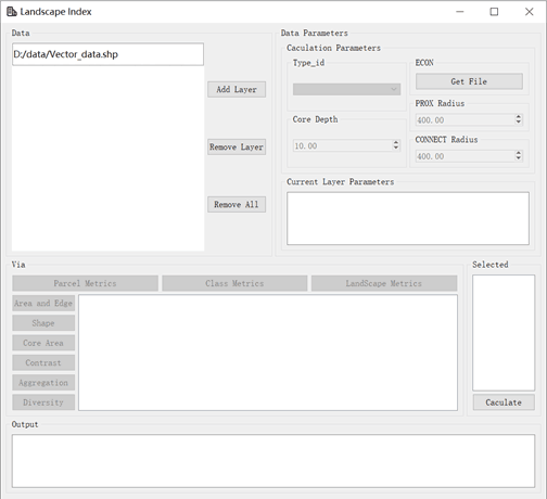
图 1 景观指数计算不再绑定地块合并
Figure 1 Landscape index and parcel merging separated into two modules
在地块合并界面中我们添加了量化邻域效应的功能。用户可以设置一定的邻域范围和间隔,软件会在该范围内自动计算出邻域内的地块数以及邻接的地块数并展示给用户,便于用户选择合适的邻域半径。
In the parcel merging interface, we have added the function to quantify the neighbourhood effect. The user can set a certain neighbourhood range and interval, and the software will automatically calculate the number of parcels in the neighbourhood and the number of neighbouring parcels within that range and show them to the user so that the user can easily choose the appropriate neighbourhood radius.
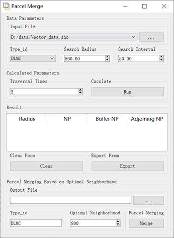
图2 领域效应探究及地块合并模块
Figure 2 Domain effects exploration and plot consolidation module
此外,矢量FoM、PA和UA等指标也被添加到VecLI中。通过用户输入矢量数据并设置原始ID、模拟ID和真实ID对应的字段,软件将自动计算相关指标。
In addition, metrics such as vector FoM, PA and UA are added to VecLI. By entering the vector data and setting the fields corresponding to the original ID, simulated ID and real ID, the software will automatically calculate the simulation accuracy.
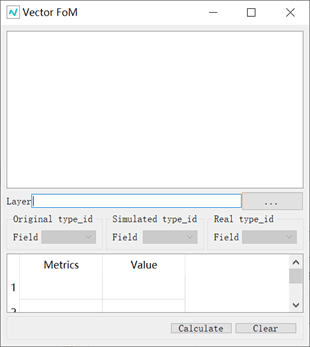
图 3 矢量FoM计算模块
Figure 3 FoM calculation module
同时,更多的指数被添加到VecLI中,目前V2.6版本一共支持218个矢量景观指数的计算,欢迎大家使用!若对软件存在疑问或需要在软件中加入新的指数,可联系程涛(Chengtaocug@foxmail.com)和姚尧博士(yaoy@cug.edu.cn)。
More indices are designed to VecLI V2.6/V3.0 beta (a total of 218 landscape indices are supported). If you have questions about the software or need to add new indices to the software, please contact Tao Cheng (Chengtaocug@foxmail.com) and Dr Yao Yao (yaoy@cug.edu.cn).
软硬件系统需求 (Software and hardware system requirements):
内存 >= 4GB (RAM >= 4GB)
硬盘空间 >= 3GB (Hard Disk Space >= 3GB)
Windows 8.1及以上版本 (Windows 8.1/10 or above)
Visual C++ Redistributable 2017
软件下载 (Binary Download)
点此下载(click here)
*2022-3-23 结果输出存在的错误已解决 (The errors in the result output have been resolved)
测试数据下载 (Test Data Download)
说明书下载 (Manuals Download)
中文 (Version 2.6)
English (Version 2.6)
参考文献 (References)
Yao Yao, Tao Cheng, Zhenhui Sun, Linlong Li, Dongsheng Chen, Ziheng Chen, Jianglin Wei, Qingfeng Guan. 2022. VecLI: A framework for calculating vector landscape indices considering landscape fragmentation. Environmental Modelling & Software. 105325:1364-8152.( Inside Website , EM&S )
Q.E.D.