


标题:VecLI v2.0.0:基于真实地块的矢量景观指数计算与分析系统软件
Title:VecLI version 2.0.0:Vector land-parcel-based landscape index calculation and analysis system
介绍(Introduction)
在VecLI v1.0.0发布后,我们随即开始了VecLI v2.0.0的开发与测试。考虑到原始版本中实现的景观指数种类较少,难以充分满足相关领域研究者和城市规划人员的研究需求。为此,我们在新版本的软件中设计了一套全新的景观指数计算模块,并提供了类型丰富、种类更多的景观指数和完善的说明文档。
UrbanComp Team started the development and testing of VecLI v2.0.0 after VecLI version 1.0.0 released. VecLI v1.0.0 was unable to fully satisfy the needs of researchers and urban planners due to small variety of landscape indices implemented. So we designed a brand new module for calculating vector-based landscape indices in this version, and provided more landscape indices and the related user manuals.
经过团队成员的调试与优化,全新推送的VecLI v2.0.0正式发布。新版本的VecLI提供了地块、类别和整体三个层次的指数,每个层次可细分为:面积和边缘指数、形状指数、核心面积指数和收敛指数。其中,地块级别指数还加入了多样性指数,用户可以在使用中根据实际需求选择。同时,考虑到使用矢量数据计算景观指数时地块破碎化的问题,我们提出了一种基于最优邻域半径的地块合并方法,在解决地块过度破碎问题的同时,提高矢量景观指数的计算效率。
The VecLI v2.0.0 provides three levels of indices: parcel, category, and integration, each of which can be subdivided into: area and edge index, shape index, core area index and convergence index. Among them, the land-parcel level indices also include diversity indices, users can choose according to their actual needs in use. A new parcel merging method based on the optimal neighborhood radius is designed to solve the problem of parcel fragmentation and improve the calculation efficiency of the vector landscape index.
在软件的设计与优化方面,新版VecLI简化了矢量景观指数计算时需要设置的参数,用户使用时更简明快捷;支持输出地块合并后的矢量数据文件,同时在属性表中写入计算的地块级别指数,方便用户后续调用;全面优化了系统的鲁棒性和健壮性,改善用户的使用体验。
VecLI v2.0.0 simplifies the parameters that need to be set when calculating the landscape index, making it simpler and faster for users to use. VecLI v2.0.0 also supports the output of land parcel merging files, and auto-modify the calculated parcel-level indices in the attribute table; it comprehensively optimizes the robustness of the program, improving the user experience.
软件下载 (Binary Download):
由于v2.0版本已停止更新,请移步到VecLI v3.0 Beta (CHN/EN Version)下载最新版本
Since the v2.0 version has stopped updating, please move to VecLI v3.0 Beta (CHN/EN Version) to download the latest version
软硬件系统需求 (Software and hardware system requirements):
内存 >= 4GB (RAM >= 4GB)
硬盘空间 >= 3GB (Hard Disk Space >= 3GB)
Windows 8.1及以上版本 (Windows 8.1/10 or above)
Visual C++ Redistributable 2017
软件展示(Demo Display):
温馨提示:如果发生视频镜像错误,请直接进入bilibili查看:点此进入Tips: If the video playback fails, please click here
VecLI v2.0.0 功能介绍(VecLI v2.0.0 features):
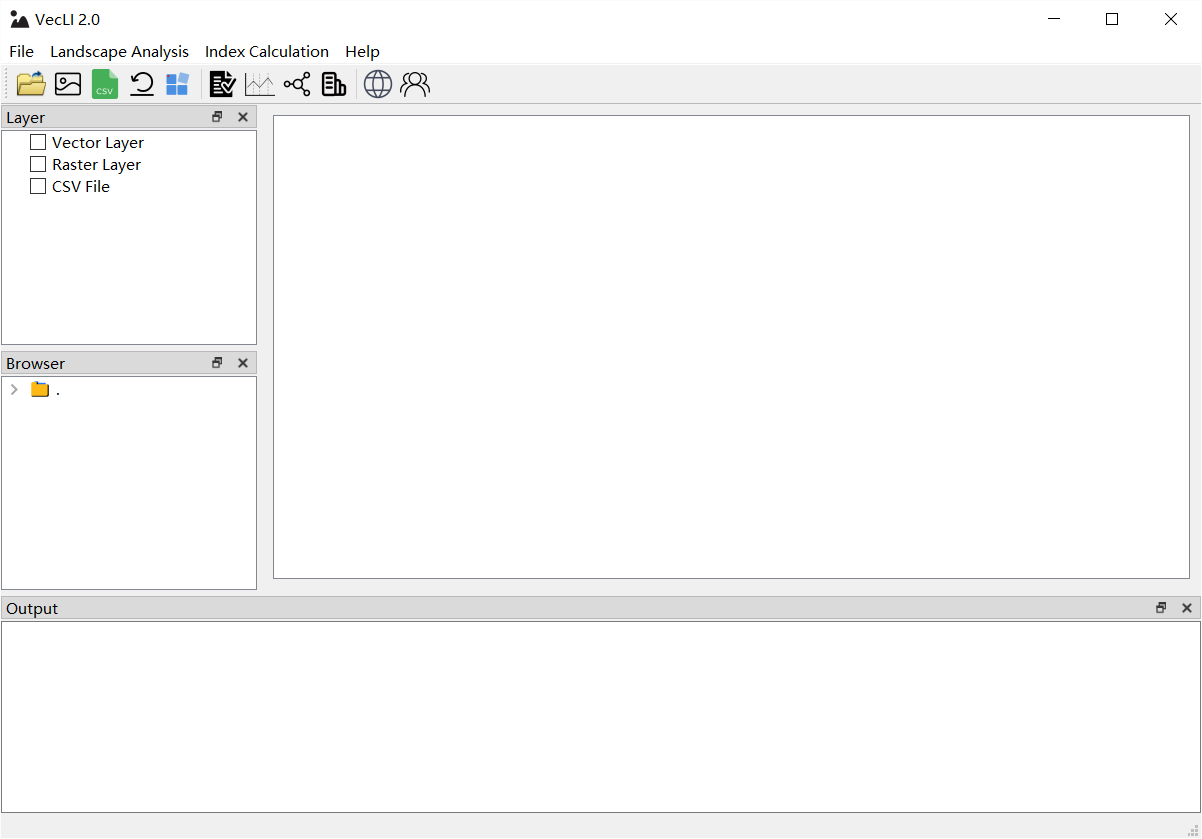
图1 VecLI 启动界面
Figure 1 User Interface (UI) for VecLI

图2 矢量图层管理界面
Figure 2 UI for vector layer management
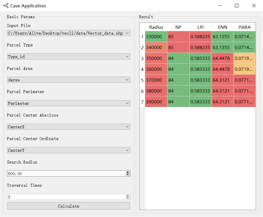
图3最优邻域半径搜寻
Figure 3 UI for optimal neighborhood radius searching
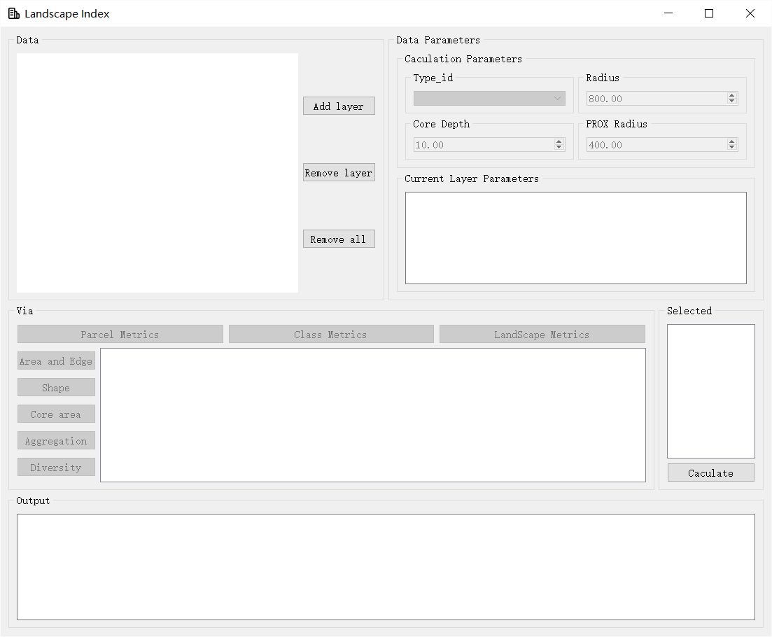
图4全新的景观指数计算模块
Figure 4 The brand-new landscape indices calculating module
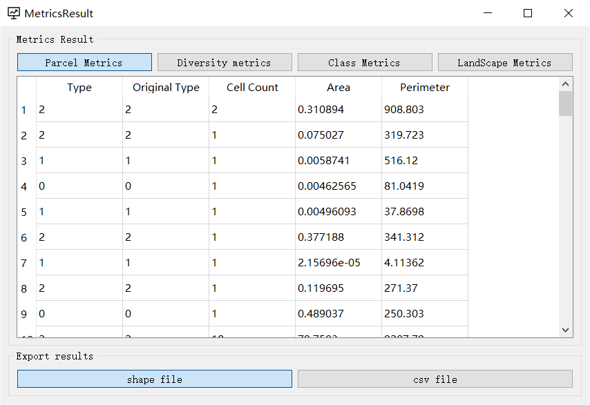
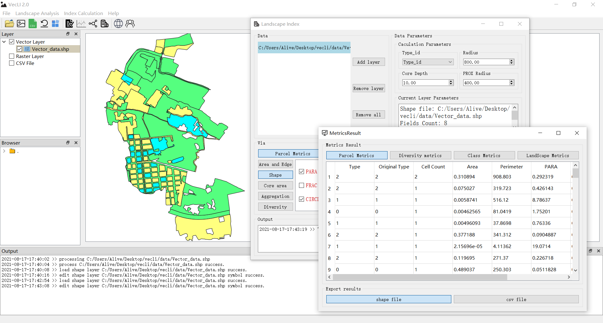
图5 结果显示和输出窗口
Figure 5 UI for result performance and ouput
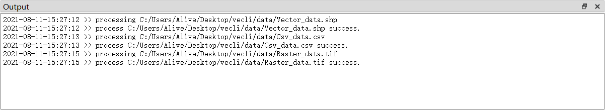
图6:实时监测和日志实时输出
Figure 6 real-time program monitoring and log info outputting
系统开发人员 (Developers):
Yao YAO, China University of Geosciences, Wuhan.
Tao CHENG, China University of Geosciences, Wuhan.
Zhenhui SUN, China University of Geosciences, Wuhan.
Linlong LI, China University of Geosciences, Wuhan.
Yuyang CAI, China University of Geosciences, Wuhan.
Dongsheng Chen, Sun Yat-sen University, Guangzhou.
Qingfeng GUAN, China University of Geosciences, Wuhan.
软件著作权(Software Copyright):
软件著作权 | VecLI:基于真实地块的矢量景观指数计算与分析系统软件[简称:VecLI] V2.0
参考文献 (References)
Yao Yao, Tao Cheng, Zhenhui Sun, Linlong Li, Dongsheng Chen, Ziheng Chen, Jianglin Wei, Qingfeng Guan. 2022. VecLI: A framework for calculating vector landscape indices considering landscape fragmentation. Environmental Modelling & Software. 105325:1364-8152.( Inside Website , EM&S )
Q.E.D.