


Abstract
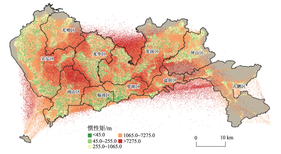
The spatial distribution characteristics and activity patterns of urban populations play essential roles in studies of spatial isolation, optimizing urban resource allocation, and so on. Because of the sensitivity of population activity data and socioeconomic data, previous studies focus mostly on the macro level. They have difficulties in dividing the socioeconomic status and quantitatively analyzing human mobility regulation. In recent years, geospatial big data, such as the mobile app data, provide us with a rare opportunity to analyze the human activity of urban internal problems. In this study, we constructed a fine-grained activity portrait of mobile phone users based on the mobile phone signaling data of Shenzhen residents, and coupled the high- resolution Shenzhen house price distribution data to achieve accurate division of people by their economic levels. Then, we extracted six activity indicators, which include the number of active locations, activity entropy, moment of inertia, travel time, travel distance, and travel speed, to quantify the spatial distribution and analyze the activity patterns of people at different economic levels. The results reveal the correlation between mobility and socioeconomic status. The distribution of people’s activities at different economic levels in Shenzhen was related to the economic development of each administrative region. The results also demonstrated that three activity indicators (moment of inertia, travel distance, travel speed) were positively related to the economic level. Residents across different socioeconomic classes exhibited different travel patterns. Likely because the rich people live in the southwest of Shenzhen, but their work locations have more self-selectivity. This leads to the distribution of home and work locations in different administrative districts and the home-work distance of high economic people are larger than others. For the other three activity indicators (number of active locations, activity entropy, travel time) that reflect the similar pattern of activity between different socioeconomic status, we found that people were mainly concentrated in living and working locations on weekdays. These locations share activities on weekdays for people at different socioeconomic levels. The socioeconomic status does not affect the number of daily activities nor the scheduling of activities. This study provides necessary data and policy guidance for government and urban planners.
摘要
有效分析城市不同经济水平人群的分布特征和活动模式对优化城市资源配置和揭示空间隔离现象有着极高的价值。 但人群活动和社会经济等级数据较敏感,使得以往研究仅停留在宏观层面,难以合理划分人群经济等级并对其空间分布和活 动模式进行定量分析。本研究以深圳为研究区,基于空间位置关联分析方法,耦合手机信令数据和细尺度房价数据实现了人 群经济水平的准确划分,通过计算活动指标定量的分析了不同经济水平人群的空间分布和行为活动特征。研究表明:深圳市 不同经济水平人群活动分布与各行政区经济发展相关,呈现“南高北低,西高东低”的格局;深圳市不同经济水平人群之间活 动模式存在差异,活动范围、出行距离、出行速度与经济水平存在正向相关;高经济水平人群职住地点相距较远,存在跨行政 区分布的现象。本研究分析了城市不同经济水平人群的空间分布特征和活动模式,对城市规划和解决社会不平等问题具有 重要的参考价值。
Q.E.D.